


UK Open Maps - GPS with Free Map Downloads and Route Finder
** Awesome GPS Toolkit for enjoying the great outdoors – Choice of 6 Map Types including detailed street mapping from the Ordnance Survey – Flick between your favourite map types to instantly view paths, contours, satellite images and street names – 100% free map downloads for offline use – Find & Follow routes near you or near other GB locations (over 100,000 routes to choose from) – Free route planning website on your PC/MAC – iPhone 5 ready **
★★★★★ “This app beats traditional mapping” - [Tech Radar)
★★★★★ “The best iPhone navigation app we’ve used yet" - [BikeRadar]
★★★★★ “Simple to use- very intuitive app” - [www.apps4outdoors.com]
★★★★★ “Extremely easy to use and looks great: an easy way to get into GPS navigation.” - [Trek & Mountain Magazine]
★★★★★ “The perfect tool for navigating the British Countryside! ” - [Scotland Outdoors Magazine]
★★★★★ “Excellent app, very useful for keen hikers.” - [Apps Magazine]
★★★★★ “Accurate mapping off-road, forget other maps and get this!” - [Acc Web]
★★★★★ “Many useful features...excellent value” - [OutDoor Enthusiast Magazine]
6 AWESOME MAP CHOICES
• Select and download map areas for free - save a fortune in map downloads!
• Choose and quickly flick between 6 different map types.
• Includes detail all the way to 1:25k and 1:10k map scales.
• Topo Maps show detailed paths and land contours across Britain for planning your trip.
• Seamlessly scroll and zoom between maps and areas.
• No need for phone signal as maps can be stored on your iPhone.
• Super fast search of 250,000 British place names.
FULLY FUNCTIONAL OUTDOORS GPS
• Record your Route with statistics; watch as it records your route on the map.
• View current speed, average speed, distance, altitude, time elapsed and more.
• In-built Compass & Direction of view.
• View current Longitude/Latitude.
• Email and share recorded routes (GPX).
ACCESS FREE ROUTE BUILDING WEBSITE- WWW.OUTDOORSGPS.COM
• Create a free Account.
• Plan, edit and share routes on your PC/Mac.
• Use our Map Search tool for finding routes all over the UK or nearby.
• View graphical elevation profiles, total climb of every route & distance.
• Seamlessly move routes between iPhone, iPad and OutDoors website in seconds.
• Import, Export and Edit GPX files.
• Download Regional AA Walk packs or Rough Ride Guides (Mountain biking routes).
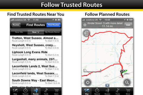
4 QUICK STEPS TO PLANNING & ENJOYING THE PERFECT DAY OUTDOORS
Step 1: FIND and download nearby routes from our growing community (over 100,000 routes).
Step 2: EDIT your routes, in the app, simply by tapping out the route line on the map (or you can build the route from scratch in under a minute!).
Step 3: FOLLOW your planned route easily and simply with no fear of getting lost! See immediately if you’re going off the planned track.
Step 4: RECORD your Route with comprehensive statistics;
― Statistics include Speed, Distance, Altitude, Duration & more.
― Watch as the app tracks your route on the map.
― Share your route on our website (Facebook, Twitter).
NOTE: Continued use of GPS running in the background can dramatically decrease battery life.